
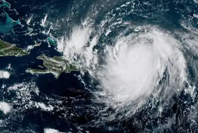
Hurricane Erin briefly strengthened into a Category 5 storm. It is not expected to make a direct hit on the United States, but to create dangerous surf.
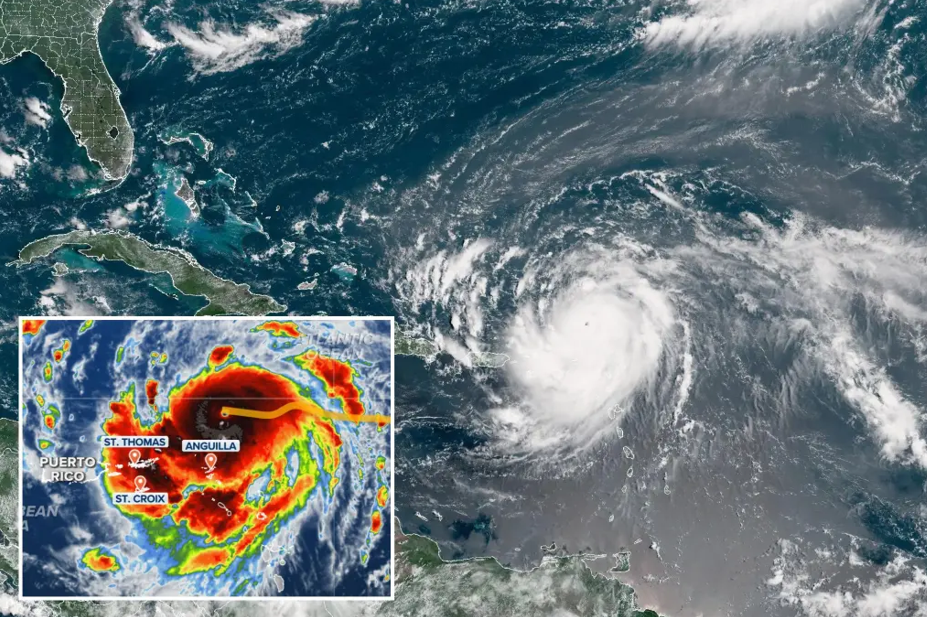
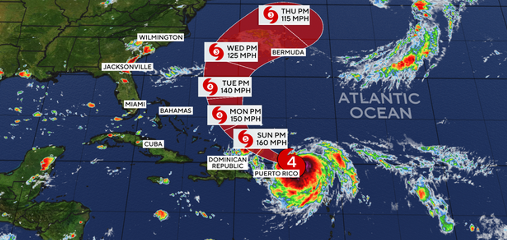
U.S. National Hurricane Center said on Saturday that Hurricane Erin has developed into a dangerous Category 4 hurricane. The NHC stated adding that maximum sustained winds have increased to 130 mph (215 km/h) with higher gusts. The storm is currently 150 miles (240 kilometers) northeast of Anguilla with maximum sustained winds of 130 mph (215 kph). It is moving west-northwest at 20 mph (31 kph). Erin is expected to produce areas of heavy rainfall through Sunday across the northern Leeward Island, the Virgin Islands, and Puerto Rico, NHC said.
Hurricane Erin tracker: Which areas are under tropical storm watches?
Anguilla, Barbuda, St. Martin, and St. Barts are all under tropical storm watches, which could bring winds and precipitation over the course of the next 48 hours.
Erin may deliver up to 6 inches of rain on Friday and Saturday as it passes close to or north of the Leeward Islands on Saturday.
Erin is expected to travel north of Puerto Rico this weekend and it may even get stronger by Sunday morning. The US Virgin Islands and Puerto Rico may receive 2 to 4 inches of rain on Saturday and Sunday from the outer bands of this storm. This could cause isolated flash floods, possible mudslides, and strong winds of 40 to 50 mph.
Large waves and potentially lethal rip currents are still predicted to approach the shore between August 20 and August 27, but most weather forecasts still place Erin hundreds of miles off the U.S. East shore.
In addition to being a risk to anyone entering the seas, erosion poses a significant risk to coastal property, particularly around North Carolina’s Outer Banks. Waves of 8 to 12 feet could hit the Outer Banks and other sections of North Carolina next week, while waves as high as 6 feet could hit other regions of South Carolina and Virginia.
Despite the possibility of powerful waves along the East Coast, a cold front that is sweeping off the coast of America is predicted to keep Erin out to sea and deliver below-normal temperatures to the Northeast next week.
The Atlantic hurricane season, which is most active in August, September, and October, continues until November 30 .
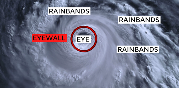
What is an eyewall replacement cycle?
The hurricane center disclosed Saturday night that Erin was undergoing an “eyewall replacement cycle,” which, according to CBS News meteorologist Nikki Nolan, is when the storm has become so significantly powerful that its eyewall, its strongest part, reaches maximum strength.
When this happens, Nolan said, the eyewall itself becomes so intense from intaking the available energy from its environment that a new eyewall will begin to build on the outside of the existing, inner eyewall. Once the new eyewall is created, it cuts off the fuel to the original eyewall.
Furthermore, as the new eyewall gains strength to keep up with the power of the storm, the radius of the eye itself will become much larger than it originally was, Nolan said.
This process may cause the storm to weaken temporarily, and its wind speeds may slow as it regains strength.
According to Nolan, however, after this process, the storm could emerge even stronger than it was before.
Hurricane Erin Landfall, Path, Weather Forecast
Hurricane Erin is currently not forecast to hit land, but strong winds are affecting nearby islands, prompting forecasters to warn of possible flooding and landslides.. The NHC said it will eventually swerve away from the continental United States.
Tropical storm watches are in place for St. Martin and St. Barthelemy and Sint Maarten. Up to 4 inches (10 centimeters) are expected, with isolated totals of up to 6 inches (15 centimeters), according to the National Hurricane Center in Miami.
Hurricane specialist and storm surge expert Michael Lowry said Erin is forecast to eventually take a sharp turn northeast that would put it on a path between the U.S. and Bermuda.
“All of our best consensus aids show Erin turning safely east of the United States next week, but it’ll be a much closer call for Bermuda, which could land on the stronger eastern side of Erin,” he said.
Erin is the fifth named storm of the Atlantic hurricane season, which runs from June 1 to Nov. 30, but the first to reach hurricane status.
“Erin is forecast to explode into a powerful Category 4 hurricane as it moves across very warm waters in the open Atlantic. Water temperatures at the surface and hundreds of feet deep are several degrees higher than the historical average,” said Alex DaSilva, Accuweather’s lead hurricane expert.
This year’s season is once again expected to be unusually busy. The forecast calls for six to 10 hurricanes, with three to five reaching major status with winds of more than 110 mph (177 kph).
The U.S. government has deployed more than 200 employees from the Federal Emergency Management Agency and other agencies to Puerto Rico as a precaution as forecasters issued a flood watch for the entire U.S. territory from late Friday into Monday.
Puerto Rico Housing Secretary Ciary Pérez Peña said 367 shelters have been inspected and could be opened if needed.
The U.S. Coast Guard said Friday that it closed six seaports in Puerto Rico and two in the U.S. Virgin Islands to all incoming vessels unless they had received prior authorization.
Meanwhile, officials in the Bahamas said they prepared some public shelters as a precaution as they urged people to track the hurricane.
“These storms are very volatile and can make sudden shifts in movement,” said Aarone Sargent, managing director for the Bahamas’ disaster risk management authority.
Maps show Hurricane Erin’s forecast path
Erin’s path continued to curve northward, with the center of the hurricane passing just to the north of the northern Leeward Islands and Puerto Rico.
The northern Leewards stretch from the Virgin Islands to Guadeloupe and include St. Martin, St. Barts and other islands. Officials had issued tropical storm watches for several islands, alerting people of the possibility of winds ranging between 39 mph and 73 mph.
A “spaghetti map” of the forecast models shows the storm skirting the Caribbean islands and remaining well offshore of the U.S. East Coast as it moves north.
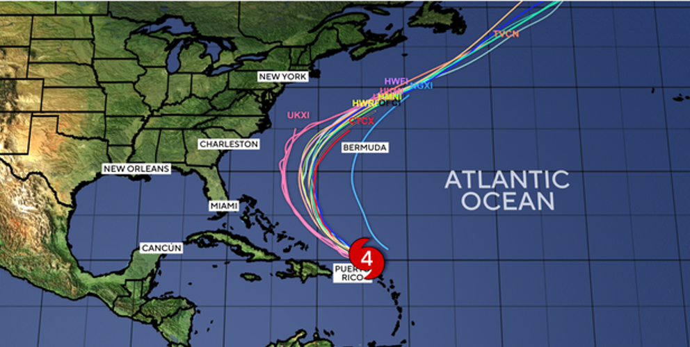
A high-pressure system in the Atlantic was expected to steer Erin away from the Eastern Seaboard while a cold front was also forecast to push the hurricane offshore, CBS News Bay Area meteorologist Jessica Burch reported.
On the U.S. Virgin Islands, officials with the National Park Service announced that sites on the island of St. Croix would be closed starting late Friday afternoon until after the storm passes.
First hurricane of the Atlantic season
Erin is the fifth named storm of the 2025 Atlantic hurricane season but the first to reach hurricane status, The Associated Press reported. Hurricane season starts June 1 and ends Nov. 30.
Colorado State University meteorologist Philip Klotzbach said Saturday on X that Erin’s earlier minimum central pressure reading is the lowest measured in an Atlantic season hurricane on or before Aug. 16 since 1979. Lower pressure is associated with more powerful cyclones.
“Since 1979, only Hurricane Allen in 1980 had a lower Atlantic hurricane minimum central pressure by 16 August,” he said.
The storm is the only Category 5 hurricane on record to form this early in the hurricane season, and the only Category 5 observed outside the Gulf or Caribbean this early in the year. It is also the 11th Category 5 hurricane in the past decade.
This year’s hurricane season is now the fourth consecutive season with a Category 5 hurricane.
Erin strengthened rapidly and is expected to grow
Erin formed as a hurricane on Aug. 15. It was the first hurricane of the Atlantic season, and quickly became the first major hurricane as well. A major hurricane is one that reaches at least Category 3 status.
“(B)y the middle of next week, Erin is forecast to at least double or triple in size, which will result in rough ocean conditions over the western Atlantic,” the hurricane center said.
Erin’s hurricane-force winds had a mean diameter of 43 miles on Aug. 16 but are expected to increase to 132 miles in diameter by Aug. 19, while its tropical storm force winds are forecast to reach a mean diameter of 385 miles over the same period.
The storm’s outer bands of rain were already beginning to impact the northern Leeward Islands, forecasters said on Aug. 16. Heavy rainfall is expected in the northern Leeward Islands, the Virgin Islands and Puerto Rico for the rest of the weekend, bringing 2 to 4 inches of rain with localized amounts of 6 inches and possible flash flooding.
In its 5 p.m. update, the hurricane center said, “Erin is expected to move just north of the northern Leeward Islands, the Virgin Islands and Puerto Rico through Sunday and pass to the east of the Turks and Caicos Islands and the southeastern Bahamas Sunday night and Monday.”
Erin’s intensity is expected to fluctuate during the next 24 hours, but it should “remain a strong hurricane during this time,” according to hurricane center forecaster Jack Beven.
“Although Erin is a somewhat compact hurricane now, the models are in strong agreement that the system will grow in size over the next several days,” Beven said in the hurricane center’s 5 p.m. update. “In fact, by the middle of next week, Erin is forecast to at least double or triple in size, which will result in rough ocean conditions over the western Atlantic.”
What impacts will Hurricane Erin have on the US?
Erin is expected to make a turn to the north and avoid making landfall altogether. It will pass somewhere between North Carolina’s Outer Banks and Bermuda, National Hurricane Center Director Mike Brennan said.
Despite staying well off the coast, Erin will cause dangerous surf conditions up and down practically the entire East Coast, from Florida all the way up to New England beaches, Pydynowski said. The conditions will include high waves and dangerous rip currents. The Outer Banks could see some beach erosion and coastal flooding from high waves, he said.
Erin is expected to bring dangerous conditions to offshore waters and beaches along the Northeast Florida coast from Aug. 18 – 21, including rip currents and rough, high surf with breakers greater than 7 feet on the 19th and 20th, said the weather service office in Jacksonville, Florida.
Weather conditions may seem ideal for a beach trip, but these types of conditions are when rip current fatalities tend to occur, Brennan said. Rip currents may not be visible from shore, so beachgoers should swim near lifeguards and pay attention to posted warnings.
Also Read :
Why Did Blue Whales Suddenly Go Silent? What Scientists Are Discovering
Helmet on Mars? NASA’s Perseverance Unveils Strange Rock Formation
Rabbit With Tentacles in Colorado: Why This Creepy Phenomenon Has People Worried
California Canyon Fire Forces Evacuations as Red Cross Ramps Up Relief Efforts